









GeoHECRAS Discount - Up to 15% off
Engineering CAD tool that provides floodway mapping, 2D modeling, GIS mapping, 3D viewing, reporting, etc.
Get discountCategory
3D CAD Software


What is GeoHECRAS?
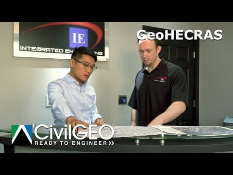
GeoHECRAS is a civil engineering software that enhances the creation and analysis of HEC-RAS models, facilitating the computation of water surface profiles for various hydraulic scenarios. It integrates seamlessly with platforms like AutoCAD, MicroStation, and ESRI ArcGIS, allowing engineers to work directly on maps and import diverse data sources efficiently.
Key features include:
– 1D and 2D HEC-RAS Modeling: Supports both one-dimensional and two-dimensional hydraulic modeling, accommodating complex flow conditions.
– Digital Terrain Cross Section Cutting: Extracts cross sections from 3D digital elevation data, utilizing sources such as LiDAR and DEMs.
– Automated Engineering Workflows: Streamlines processes like bridge and culvert design, FEMA floodplain encroachments, and model calibration.
– CAD and GIS Integration: Ensures compatibility with various CAD and GIS platforms, enhancing design efficiency and accuracy.
– 2D and 3D Visualization: Offers dynamic viewing perspectives to identify and address modeling issues effectively.
– Automated Reporting: Generates comprehensive reports tailored to project requirements, facilitating documentation and review.
These features collectively improve the efficiency and accuracy of hydraulic modeling and floodplain analysis.
Looking for a great deal on GeoHECRAS?
Good news! GeoHECRAS is currently offering discounts of up to 15% off regular subscription rates. This is your chance to leverage premium photo editing tools to enhance team coordination and productivity at a significantly reduced cost.
- Rapid HEC-RAS model creation and review
- Seamless integration with CAD and data
- Compute accurate water surface profile data
- Comprehensive floodplain and hydraulic system analysis
- Interactive interface with online data library
- Exceptional technical support and customer service
Eligibility
Number of Seats/Users: GeoHECRAS offers discounts based on the number of users or seats. A higher volume typically leads to a better discount structure, especially for enterprise-level usage.
Commitment to a Long-Term Contract: Discounts are often provided to companies that commit to using the service for a longer period (e.g., 1-year or 3-year contracts). A longer commitment shows GeoHECRAS that the company is serious and willing to invest in the platform long-term.
No Active Discounts: Companies that are not already receiving other active discounts may have a better chance of qualifying for additional discounts from GeoHECRAS. GeoHECRAS reserves discounts for new customers or those not currently under promotional pricing.
Volume or Usage Commitment: GeoHECRAS offers discounts if you agree to a minimum amount of usage or transaction volume. This could be based on data storage, transactions, or other metrics tied to how much you will use the platform.
Enterprise-Level Negotiation: Companies that qualify as “enterprise” due to their size or complexity (e.g., having large teams, multiple departments, or geographical presence) may be eligible for additional discounts from GeoHECRAS. Such companies are often in a position to negotiate for better pricing.
Early Renewal or Prepayment: GeoHECRAS often offers discounts if you renew early or prepay for the entire contract period. This is a common approach to securing a lower price.

GeoHECRAS - Up to 15% off
Reviews
Our internal data shows that Spendbase clients consistently praise GeoHECRAS for its time-saving benefits and ease in hydraulic modeling. Across the top 25 upvoted insights, several key themes have emerged that highlight both its strengths and some areas for improvement.
Key Strengths:
• Quick and Efficient Modeling – Clients report that the software dramatically reduces the time to build and update HEC-RAS models. Many have seen models that normally take weeks constructed in just days or even hours. This speed advantage, often mentioned along with precise floodplain mapping, is noted as a major benefit.
• Seamless Integration – Spendbase clients appreciate how GeoHECRAS works in tandem with CAD, GIS, and various data sources like LIDAR. The ability to import/export files and integrate different file types is seen as a major plus. The software’s compatibility with Civil 3D and the ease of switching between models helps maintain a smooth workflow.
• Strong Technical Support – Our internal trends reveal frequent praise for the responsive, knowledgeable technical team. Clients mention that advice and technical help—sometimes via direct phone support—consistently enhance their overall experience.
• User-Friendly Interface – Many clients note that GeoHECRAS is intuitive, even if there is a short learning curve. Its ability to visually display hydraulic modeling steps, from cutting cross sections to editing geometry, makes the workflow less cumbersome and helps with both new hire training and routine tasks.
Areas for Improvement:
• Occasional Software Bugs – Some clients report minor glitches especially when handling large or complex CAD files. While these issues are generally resolved quickly through updates and support, they have been noted as occasional interruptions.
• Performance on Large Datasets – There have been comments that processing very large files may sometimes slow down the interface. It is advised for users to consider local saves or hardware updates to maximize performance.
• Additional Functional Enhancements – There is some interest in expanded capabilities like better guidance for modeling hydraulic storage areas upstream and improved map navigation while editing. Spending some additional focus on these areas could further improve overall satisfaction.
Overall, our internal data confirms that Spendbase clients find GeoHECRAS to be a robust tool for hydraulic modeling, appreciated for its efficiency, integration capabilities, and excellent technical support. The strengths far outweigh the few minor drawbacks, making it a valuable asset for streamlining complex engineering projects.
See how much you can save on your stack
Pick your team’s tools!
Click to select one or more tools.


What’s your company size?
Just click to select.
What’s your business email?
We'll send you calculations right away
The email is flying to your inbox!
Beyond discounts, you may qualify for up to $100K in AWS credits.

FAQ
1. What types of discounts are available for GeoHECRAS?
We offer seasonal, volume, academic, and renewal discounts depending on eligibility and specific promotions running at the time of purchase.
2. Is there a student or educational discount for GeoHECRAS?
Yes, students and educational institutions can receive special academic pricing. Please contact our sales team to verify eligibility and receive a quote.
3. Can I get a discount if I purchase multiple licenses of GeoHECRAS?
Absolutely! We offer volume discounts for multi-license purchases. The more licenses you buy, the greater the discount.
4. Are temporary or trial licenses eligible for discounts?
Discounts typically apply to perpetual and subscription licenses, not to temporary or trial versions, which are often free or available at a minimal fee.
5. Do you offer discounts for non-profit organizations?
Yes, eligible non-profits can request special pricing. Please contact our support team with your organization details to explore available discounts.
6. How can I find out about the latest GeoHECRAS discount offers?
We announce discounts via newsletters, social media, and our website. Subscribe or follow us to stay updated on current promotions.
7. Can existing GeoHECRAS users get loyalty discounts when renewing or upgrading?
Returning customers may be eligible for loyalty or renewal discounts. Reach out to our sales team before your license expires or prior to upgrading.
8. Are GeoHECRAS discounts applied automatically at checkout?
Some promotions apply automatically, while others require a coupon code. Check the offer details or contact support for guidance during your purchase.
Related discounts

MakeHuman
3D CAD Software
Up to 15% off

Ansys Cloud Direct
3D CAD Software
Up to 25% off

Lantek Flex3d
3D CAD Software
Up to 35% off

Carbon Design Engine
3D CAD Software
Up to 30% off

Geomagic Control X
3D CAD Software
Up to 30% off

Innoplus
3D CAD Software
Up to 25% off
Software cost optimization
GeoHECRAS savings in five steps
Let’s estimate your potential savings and see how you can scale your cloud infrastructure.
One call. No cost. No commitments


meet vendor relationship EXPERTS
Our customers save millions with us



Save on GeoHECRAS
It’s time to shrink your bill
Let our SaaS cost optimization experts check what deals you can get and how much you can save on your corporate subscriptions
See how you can:
- Learn about pricing benchmarks and discounts
- Present potential savings by vendor to your team
- Meet your SaaS and cloud cost optimization goals
Get GeoHECRAS discount
We’ll email you back within 1 business day